Hang
Gliding Association of WA
Margaret River Region Site Guide
Area Overview
This guide covers the area from Bunbury to Cape Naturaliste. Margaret River is
about in the middle, and is a nice place to stay. The coastal sites in the area
cover wind directions from NE right around through W to Southerly. Probably best
in spring/autumn area when you can take advantage of westerly pre and post frontal
winds, but flying is may also be possible on the weaker sea breezes in summer.
Index of Sites
Brunswick Junction
A big westerly hill on the Darling scarp, good thermalling potential.
Site Type
|
Direction
|
Rating
|
Take off Altitude
|
|
Inland Hill
|
W
|
Novice
|
about 600 ft
|
Getting There:
On the Darling Range south of Brunswick Junction (about 200km south of Perth on
the south west highway). If you haven't been here before, contact Cloudbase Paragliding
Club (See the main page for club contacts), check on the current access arrangements,
and preferably organise your first flight with a club member who has good knowledge
of this site. This site is privately owned, so is sensitive and could easily be
lost. We have access only as guests of the owner. The site is locked and
the owner must be contacted prior to each visit to get keys.
Flying:
The hill is quite flat, with a small steep lip at the top, so thermal lift is
probably required for a decent flight, and ground clearance will be limited after
launching - be careful.
Good potential for crosswind cross country flying 100km plus along the darling
range. Better downwind potential than serpentine due to farms and Collie behind..
Site Records:
none
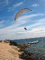
Bunbury
A nice long low coastal dune site which takes a W wind, features easy access
and a nude beach.
Site Type
|
Direction
|
Rating
|
Take off Altitude
|
|
Low Coastal Ridge/Dune
|
W
|
Novice
|
0 - 30 ft
|
Getting There: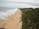
From Bunbury head north along the coast, choose a car park and fly.
If approaching south turn down Washington Dr (at the caravan park) just before
you hit the 90 zone on the outskirts of Bunbury. Take this to the end, turn right
and follow this road until you reach the beachside carparks. Launch from
the beach.
Flying: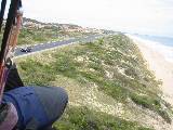
Good coastal flying.Avoid damaging the dune when launching. Road and
powerlines behind the ridge in some areas so be extra careful in strong winds.
Low sites can be dangerous too. Potential for several km of flying south down
the beach to Dalyellup and Beyond.
Dalyellup
A nice long low coastal dune site which takes a W wind, features easy access and
a nude beach.
Site Type
|
Direction
|
Rating
|
Take off Altitude
|
|
Coastal Ridge
|
W
|
Novice
|
0-30 ft
|
See bunbury above, this is the same dune, accessed from further south.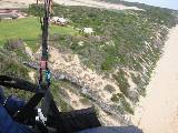
Take the Vasse highway out of Bunbury towards Busselton, and the first right
after the servo will be signposted to Dalyellup housing estate. - find your
way to the beach and fly.
Yallingup - 3 Bears
A nice long low coastal dune site which takes a W wind, features easy access
and a nude beach.
Site Type
|
Direction
|
Rating
|
Take off Altitude
|
|
Coastal Ridge
|
W
|
Novice
|
? ft
|
Getting There:
From Dunsborough head towards Cape Naturalisteturn left off sugarloaf rock
road onto a 4WD track once you are on that you cant miss it. Keep 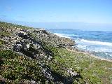 driving
till you find the main carpark. It has a toilet and stairs to the beach. Drive
past this to the next carpark which is the old one. If you walk north through
short scrub on the track that is already there, you come to a huge clearing which
is all sand and on about a 15 degree slope.
driving
till you find the main carpark. It has a toilet and stairs to the beach. Drive
past this to the next carpark which is the old one. If you walk north through
short scrub on the track that is already there, you come to a huge clearing which
is all sand and on about a 15 degree slope.
Can be approached from Yallingup on the same sand track, but needs a
vehicle with decent clearance to clear limestone outcrops (standard subarus
don't make it).
Click Here for map
Flying: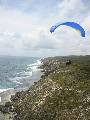
Launching from here is wonderful, plenty of space for novices to get pushed around
and a clear ridge just in front. The ridge gets really high to the right and to
the left its great too. Anyway you can see it from Yallingup. I don't have much
detail for this site, usual precautions for the coast would apply, watch out for
stronger winds approaching, don't take any risks with landing in the water (there
are cliffs into the ocean in places).
Yallingup - Rabbit Hill
A big coastal site which takes a W wind, easy 2WD access.
Site Type
|
Direction
|
Rating
|
Take off Altitude
|
|
Coastal Ridge
|
W
|
Novice
|
100 ft ?
|
Getting There: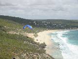
From Yallingup go to the farthest beach carpark north. Walk along the foot
path up to the lookout, HG can launch from here, it's awkward for PG. A
better PG launch is about 2 minutes walk along the path where there is a clearish
area beside the track. This is the same ridge as 3 bears, but a lower launch.
Flying:
Takeoff is higher than it looks, and provides enough height to glide across
to the sea cliffs to the north if the wind is on. If its too light to get
up then 3 bears might still work. Launching is small and a
bit prickly, be courteous to walkers using the path. Plenty of beach
to land on. Stay off the dune vegetation and use the path if you
need to walk up.
Good potential to soar the coastline if the wind is on.
Don't get caught low on the sea cliffs as they drop straight into the ocean.
Watch out for increasing winds, and be aware that because the launch is
low wind strength may increase as you gain height.
The wind seems to often be lighter here than further south, may be worth
a look if its a little too strong at Contos.
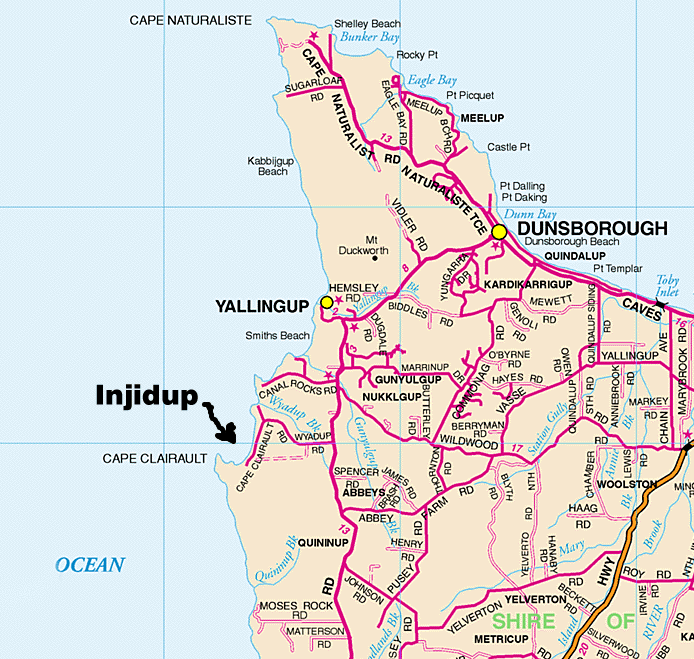
Injidup
A low coastal site which takes an excellent range of wind direction from
NE to N to W and even SW and features a large bare sand dune facing north.
Site Type
|
Direction
|
Rating
|
Take off Altitude
|
|
Low Coastal Ridge/Dune
|
NE, N, NW, SW
|
Novice
|
0 - 70 ft
|
Getting There: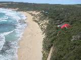
From Margaret River head north along Caves Rd, turn left at Wyadup Rd, just before
Canal Rocks, about 50km from Contos. If approaching from the North it's obviously
on the right just after Canal Rocks. A bitumen road takes you to a turnoff on
the left for Injidup beach parking area. Walk south down the beach to the sand
dune for a northerly or north-easterly site, north for a westerly or south westerly
Location Map
Flying:
The dune is excellent for beach launching, trees to the north of the dune produce
a surprising amount of lift, probably due to the big hill behind. Be careful of
large trees at south end and road behind ridge top at far northern end.
Back to Top
Moses Rocks
A nice low coastal site which takes a W wind, features easy access
- a launchable carpark, nice coastal scenery.
Site Type
|
Direction
|
Rating
|
Take off Altitude
|
|
Low Coastal Ridge
|
WNW
|
Novice
|
0 - 60 ft
|
Getting There:
Moses Rocks Road runs out to the coast from caves road a few km south of
Injidup (see inkidup site guide here) when you hit the coast take the track
to the right (north) to the carpark at the end. Launch from the carpark.
Location Map
Flying: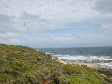
Good coastal flying. Beach is quite narrow and rocky, and not visible from launch,
take a walk down and check you're happy with it before you launch. Nice
flying to north and south of launch. Scope to go further to the north for
experienced pilots, jumping some gullies leads to some interesting flying
with higher red rock cliffs but limited landing options. Launch and toplanding
in the sandy car park is good, but watch out for cars.
A good option if the wind is a bit too strong at Contos.
Conto Springs
One of the best known coastal sites in WA, a large coastal site suitable
for beginners with impressive limestone cliffs, good access and a popular
surfing beach and camping area and rock climbing nearby.
Site Type
|
Direction
|
Rating
|
Take Off Altitude
|
|
Coastal Ridge
|
WNW to WSW
|
Novice
|
200 ft
|
Getting There: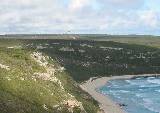
From Margaret River head south along caves Rd to the Lake Cave turnoff on the
right, turn in here. Before the kiosk and cave turn left onto a well signposted
dirt road to conto springs. Carry on past the camping area toward the beach. Just
before descending to the beach are 2 footpaths on the right marked with pine poles.
These lead to the take off. To drive to the bottom landing carry on down the road
and turn right to the beach parking area. It's a popular beach so your chances
of getting a lift up after a bomb out are pretty good.
Flying:
Small take off right in the lift band if conditions are good. Be ready
to be plucked off the ground as soon as the glider is inflated. Beware
of rotor from left ridge if wind is off to the South. The take off is in
a bowl which wind tends to wrap around into. Watch the waves to help juidge
true wind direction as a northerly or even NNE can feel like a westerly
at launch, but doesn't feel the same when you try to launch. The ridge
can be flown for a considerable distance both north and south of the bowl
depending on wind direction. Land in grassed picnic area near carpark or
on beach. Top landing is possible, but difficult due to the small launch
area, and usually involves dropping your glider into the bushes if successful.
Back to Top
Cosy Corner
I haven't actually flown here, but it looks like a nice southerly site.
Site Type
|
Direction
|
Rating
|
Take Off Altitude
|
|
Coastal Ridge
|
SSW-S
|
Novice
|
0-100 ft
|
Getting There:
The Cosy Corner off caves road between Conto's and Greenhills, drive to
the carpark, and you should be able to launch there if its empty, also
potential to beach launch.
Flying:
Haven't done it yet, looks like an avrage medium low coastal site, overhung
cliff in front of the carpark with some rock climbs, watch out for turbulence
above it.
Greenhills
A very long coastal ridge, good flying.
Site Type
|
Direction
|
Rating
|
Take off Altitude
|
|
Coastal Ridge
|
SW
|
Novice
|
250 ft
|
Getting There: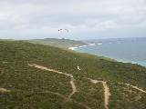
Set your trip meter to zero at the start of Hill View Road in Augusta and look
for a track on your left heading south at 5.4 Km about 1 km of sand track
sometimes OK for 2WD, but can develop blowouts.
Flying:
Good site with variety of ridge shapes from rolling hills to cliff. Site
often provides good ridge and thermal lift and can be flown in light and
strong wind. The route for the local scenic aeroplane flights goes right
over the site so watch for them - especially if youre high. If it looks
like a good day you might even stop in at the airport to let them know.
Carry communication as the site is big and long.
Take Off. All take-offs are in the bush so select the clearest
spot with the best interrupted air flow and not behind any steps in the
ridge. Watch the bushes in your lines.
Landing. There are lots of options for top landing on
the side of the ridge. Stay away from gullies and sharp edges - there is
generally little rotor or turbulence in clear areas. Landing is in
the bush so pick a patch that doesnt look too high. Bottom landing is
possible on the beach in some areas but getting up the cliffs could be
a problem. Bottom landing may disappear at high tide.
Back to Top
Pt Matthew
S and SE flying near Margaret River, but not an easy site to fly safely.
Site Type
|
Direction
|
Rating
|
Take off Altitude
|
|
Coastal Ridge
|
S, SE
|
Intermediate
|
100 ft
|
Getting There:
South from Augusta along Cape Leeuwin Rd. Ask someone who's been there.
If you know more send me an e-mail.
Flying:
Very tight landing areas, people have had to land on the road. Watch out
for power lines. hazardous site, quick condition changes.
Worse for hang-gliders, advanced site for them.
Back to Top
Sarge Bay
Southerly stronger wind site near Augusta
Site Type
|
Direction
|
Rating
|
Take off Altitude
|
|
Low Coastal Dune
|
S, SE
|
Intermediate
|
0-20 ft
|
Getting There:
7.1km South from Augusta along Cape Leeuwin Rd, carpark on right signposted
as Sarge Bay. Walk 100m or so west along the beach to a small rocky point.
Dune runs west from here.
Flying:
Low dune so needs a fairly strong breeze. Flat top of dunes so relatively
safe if blown back.
Back to Top
Created by Mike Dufty/MikeDufty@Yahoo.com/last updated 14 October 2003©